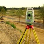
Topographic Surveys
Whether you are developing a plot of land, designing a housing scheme or road, a commercial premise or a single house you will probably require a topographic survey showing the existing features, the terrain and extremities prior to development.
Land / Topographic Surveys
GPS Surveys
Earthworks/ Volume Surveys
Boundary Surveys
Land Registry
As Built Surveys
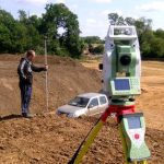
Land / Topographic Surveys

Typically surveys will include:
- All existing topographic features including boundaries, buildings, roads, trees, street furniture, surface changes.
- Heights can be related to a local datum or Ordnance Survey datum
- Heights can be shown at roof, soffit and ground level to enable design to suit adjacent properties and planning requirements.
- Adjacent properties and roads are shown as an aid to design.
- Drainage information can also be collected showing the cover and invert level, pipe size and direction of flow.
- All surveys are plotted at a suitable scale (1:200 or 1:100) to fit on an A0, A1 or A3 sheet.
- Drawings are produced in AutoCAD (DWG) and PDF formats in either electronic and /or paper form and sent to the design consultant / client.
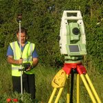
GPS Surveys
 If the survey requirement requests that all co-ordinates are related to the Ordnance Survey grid we can provide a survey using the following criteria:
Earthworks/ Volume Surveys
Boundary Surveys
Land Registry
 If you have a plot of land, a property you are selling or a commercial premise that is not registered then we can produce a fully compliant plan recognized by the Land Registry
As Built Surveys